Archive 17/01/2023.

Free Terrain Editors

rasteron

Here are some FREE Terrain/Heightmap editors that I have gathered and tested, language denotes opensource licensing.

TerreSculptor HMES (Alpha, Windows)
Lithosphere (Python)
Scape Editor (Binaries, C++)
L3DT Standard Edition (Free, Windows)
Torque3D Terrain Editor (Windows/Linux, C++)

Updated/Suggestions:
IrrRPGBuilder (MIT/X11)
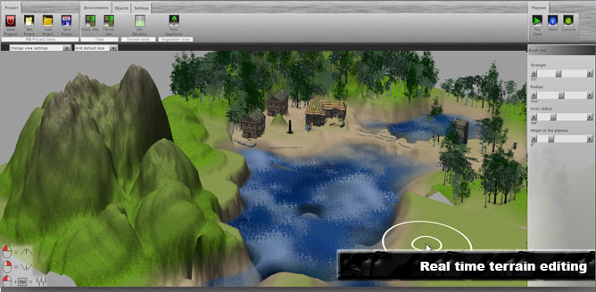
Artifex Terra 3D (Free, Windows)

cheers :slight_smile:

christianclavet

Hi,

There is also this one that I made with a friend (Andres Jesse Porfirio) with Irrlicht (Windows/Linux C++). It can save tiles in OBJ or Collada
http://irrrpgbuilder.sourceforge.net/ License is MIT/X11

Shylon

Thanks for links, very useful editors. :slight_smile:

jmiller

Blender and Urho seem to handle Terrain at 2048+ for me.

Ant Landscape for Blender.
https://wiki.blender.org/index.php/Extensions:2.6/Py/Scripts/Add_Mesh/ANT_Landscape

A method to create and manipulate height maps by linking to a plane and rendering as greyscale:
http://blender.stackexchange.com/questions/9030/create-and-manipulate-height-map-save-as-greyscale-texture

Bananaft

Also, there are real world elevation data with with 30m resolution, avaliable for everyone. I was downloading it from here: gdex.cr.usgs.gov/gdex/ . It requires registration, and there may be other sites, where it can be downloaded.
en.wikipedia.org/wiki/Shuttle_R … hy_Mission

rasteron

This is great guys and this thread is also meant for you to share your own findings and feedback.

@christianclavet

Yes, that is also one cool editor that you guys made with Irrlicht. Thanks for sharing!

cheers :slight_smile:

Nauk

Hello everyone,

you can always have a look at “Artifex Terra 3D”, also free (as in beer) and I am always very happy about feedback and critics. :slight_smile:
I am currently in the process of reworking it and making it more agnostic and open, as in integrating assimp and plugins - specially export / import geared towards various engine formats.

edit I am also happily assisting with material conversion.

Cheers,
//Nauk

rasteron

Hey Nauk,

Welcome to the forums! :slight_smile: Yes, I got to try Artifex Terra when I was doing Ogre3D some time ago, and it really is a great terrain editor!

Here’s my built and a little test video 2 years ago :mrgreen:

I just thought it was more focused on Ogre3D so I did not include it on this list but it’s good to hear if you do have plans of making it agnostic/open and Urho friendly. :wink:

Added now!

Nauk

Nice Video :slight_smile: Thanks for adding me!

//Nauk

slapin

Hi, all!

Please tell me which of terrain editors can be used with Urho3D terrain node? Or is there any reason in using it?
Sorry for probably stupid question - I never used terrain before, but tried it in Urho and don’t quite understand the workflow.
I tried using Terrain in Unity and see it as powerful tool, but is there something for Urho?

artgolf1000

World Machine is the most powerful terrain tool, but it is a paid software, I have used it for several years.

HeadClot

Just thought I would chime in on this thread.

TerraSculptor is really awesome and really overlooked. :slight_smile:

http://www.demenzunmedia.com/home/

lhlvieira

Wilbur. Its more of a height map editor than a terrain editor.
http://www.fracterra.com/wilbur.html

JTippetts1

I took a look at that Wilbur tool. It has a few nifty little tricks. One in particular that is mentioned in the tutorials, basin filling, led me to a paper about implementing a basin filling algorithim. I decided to implement a similar technique in my own terrain editor based on that paper. For such a simple trick, it sure is handy for making terrains flow and drain more realistically.

smellymumbler

One feature that isn’t very appreciated in terrain editors is the ability to stamp heightmaps. Having a good collection of height stamps gives freedom to level designers to create playable designs, without sacrificing “good” looking landscapes.

smellymumbler

Also cool: this guys allows you to shade your terrains procedurally, but also exports a bitmap. So you can generate a heightmap, put through this, export a height, and then use in any other engine.

https://assetstore.unity.com/packages/tools/terrain/cts-complete-terrain-shader-91938